Simultaneous Stories So Far...
Urban Assemblies: the vacancy Phenomenon
Greenbelt of Ahmedabad
Planning process byproduct
Story so far

INFRASTRUCTURAL LEFTOVERS OF AHMEDABAD
WHAT ARE INFRASTRUCTURAL LEFTOVERS?
Undesired, unused, devoid of any urban activity, form or function; their only identity is that of a leftover from construction of large-scale infrastructure. Our cities host these chains of trapped potentials which are present amidst the dense urban fabric.
WHY ARE THEY LEFT OVER?
The accepted trend of building infrastructures is to prioritize the technicality of construction rather than considering them as an opportunity to build active urban spaces. The three major cause are
- It is because of the budgeting structure of projects. Money is sourced from different government bodies.
- The authority of each project lies with different government organizations like municipalities , Central government, State government etc.
- Political influence on projects heavily decide their timelines , budgeting, planning, etc., therefore a lot of the parameters of the entire project depend on the political characters and agendas of that time.

Brief history of Ahmedabad's infrastructural projects; the emergence of infrastructure leftovers
History of emergence
There was political unrest in Gujarat / Ahmedabad in the 60s. There was political unrest/ wars in India in general. Rising RSS popularity conflicting with the newly formed INC
Gujarat was just separated from Maharashtra in 1960. The state government was still new and struggling to stay in power due to RSS and the Indira Gandhi government's party split.
Communal tension and the riots in the state. Therefore the already unstable government's priorities and political will lay elsewhere and not so much on the development front.


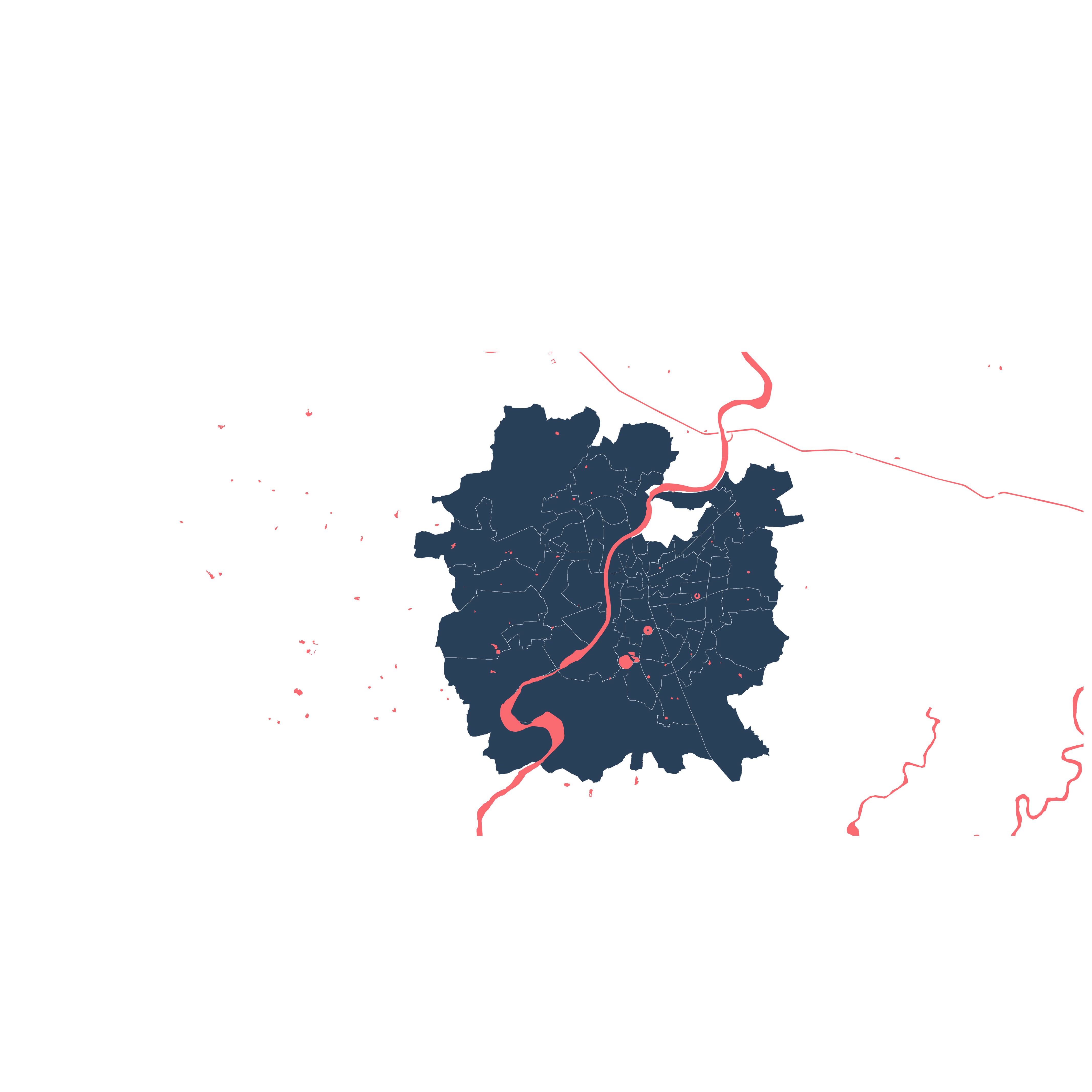
SABARMATI RIVER
19th century Ahmedabad, the Sabarmati river banks were used for domestic purposes like washing clothes etc.


BB&CIRC (1855)


Ellis Bridge

In 1881, the Government constructed a canal known as “Khari Cut” having a length of about 80 Km, width at bottom 10 meters and above 20 meters, which originates at village Raipur, to convey waters from River Khari to the Chandola Lake


BB&CIRC (1855)

Completion of the BB&CIRC line of 304 miles was completed.
By 1874, 85% of the cotton was transported through the railways in Ahmedabad, surat Bharuch.
Also, the railways were essentially created for the benefit of the British, who had settled into India by then. (After the mutiny of 1857 they wanted to strong hold their claim on India.) For the easier transportation of raw materials , the railways were built on public money. Indians were buying finished cotton fabric (imported from Britain). So basically Indians paid for the railways which would take THEIR raw materials to Britain where they would make the finished goods AND sell it back to India .
Speculation

SABARMATI RIVER
19th century Ahmedabad, the Sabarmati river banks were used for domestic purposes like washing clothes etc.
The first Railway Station built in Ahmedabad at Kalupur.

Ellis Bridge destroyed in floods
Railway tracks laid
Bombay Baroda & Central Indian Railway company (BB & CIRC) entered into contract with the East India Company to build a line along the coast from Surat through Gujarat to Ahmedabad.
Bombay Baroda & Central Indian Railways company was created by Lieutenant-Colonel French who was an acting resident in the court of the Gaekwads and John Pitt Kennedy.
BB&CIRC was funded by the Government of India ( under the British). The money was public money , the contractors were British engineering companies, who charged double the money . The public money was collected through tax. So, it was the Indian's who paid for indirectly double for the railways to be constructed. ( Shashi Tharoor, An era of Darkness, 2016)
BB&CIRC (1855)


This was with a view to provide irrigation water to the agriculture lands, measuring approximately 10,200 hectors of 110 villages of Daskroi Taluka, of Ahmedabad District and of Mahemdabad Taluka of Kheda District. Khari Cut canal passes through eastern part of Ahmedabad City. It is a water reservoir, embanked and circular in form. It is also home for cormorants, painted stocks, and spoonbill birds.
The British were interested in only a few Indian crops that could be brought into the global market by them. Commercial crops like rice, cotton , wheat etc. They made infrastructures like canals to support this endeavor, which was funded the public money ( tax payers ).
_edited.jpg)
In the year 1909 on a complaint by some villagers known as “Kalambabdhi” villages, the Government officers either asserted that their rights were not being interfered with, or allowed the water to flow in the Khari River according to their requirements. A suit was filed and ultimately, the High Court of Bombay finally disposed of the matter.
It was pointed out that “Between 1878 and 1881, the Khari Cut was built, which was a canal taking off from the Khari River at Raipur and designed to irrigate Ahmedabad lands and to fill the Chandola lake, three miles south of Ahmedabad.” The High Court vary the decree by declaring that the plaintiffs have the right of riparian owners to the water of the Khari River accruing from natural sources and that the defendant should be enjoined from diverting to the Khari Cut Canal any of the Khari River water which has not been put into the River by artificial means so long as water is required for the Kalambandhi villages.
Thereafter, there was an agreement between the Government of Bombay and Kalambandhi villagers for the waters of Meshwa Canal on 22nd January, 1948.

BB&CIRC (1855)


In order to bring about greater efficiency in administration, speedy implementation of on-going projects, better customer care, reduction of workload on General Managers etc., Indian Railways have decided to create seven new zones by territorial re-adjustment of existing zones. The new zones, having limited financial burden on Railways, will have thin and lean, efficient and modern administrative set up. Two of the new zones have already started functioning.
1951
The Western Railway was created on 5 November 1951 by the merger of several state-owned railways, including the Bombay, Baroda and Central India Railway (BB&CI), and the Saurashtra Railway, Rajputana Railway and Jaipur State Railway. The narrow-gauge lines of Cutch State Railway was also merged into it in 1951.
"Present day Railway junction modified along with railway yard and was commission in 1969 to accommodate the need of passenger and freight traffic such as increase in number of platform , second class waiting room etc."

The farmers are supplied with semi treated water for irrigation but for the same price of fresh water.
Pollution in the canal, the bifurcation of canal, one channel leading towards Chandola Lake and the other towards STP. The farmers are charged for canal water but unfortunately, they are supplied with sewage/trade effluent.
1969

SABARMATI RIVER
19th century Ahmedabad, the Sabarmati river banks were used for domestic purposes like washing clothes etc.

Godhara Riots
In September 2002, there was a terrorist attack on Akshardham temple complex at Gandhinagar.
Venkatachaliah Commission to recommend changes: for a response from Constituition to changing needs of effective governance and socio economic development
Parliament attack in December 2001
Gujarat was hit with a devastating earthquake on 26 January 2001 which claimed a staggering 20,000 lives, injured another 200,000 people and severely affected the lives of 40 million of the population.
Patel resigned as chief minister in October 2001 due to his failing health.
Railway lines from Gandhinagar city to connect to Ahmedabad were constructed. The lines were connected to Gandhidham - Sabarmati line.


Fig: Major stations
The railways stations capture a huge area of vacant lands owned by the central government

BB&CIRC (1855)


In 1976, a group of local professionals came together as the River Front Development Group to propose an incremental approach to creating a public riverfront. Thus, there has been a long-standing acknowledgment that the riverfront can be turned into a major urban asset from its present undesirable state.
A special purpose vehicle titled Sabarmati Riverfront Development Corporation Limited (SRFDCL) subsidiary (Sp Purpose Vehicle) under AMC was formed to develop the city's riverfront. in May 1997 funded by the Government of India with a seed capital of ₹1 crore.
1992, the National River Conservation Plan proposed construction of sewers and pumping stations to reduce water pollution. (Talks of riverfront development had been around since some 30 odd years already.)
The edge conditions previously were mostly informal settlers. People who had been settled there since housing for them wasn't available, they couldn't afford rents. Previous mill workers?
The river banks weren't used by the locals like before for domestic purposes so the edges were occupied the next in immediate need.
Project Proposal jointly prepared by AMC and Environment Planning Collaborative led by architect Bimal Patel (EPC was involved primarily as a planning consultant)
The project extended to cover an 11.25 kilometres (6.99 mi) stretch and reclamation of 202.79 hectares (501.1 acres) and was put on fast track.
The project estimated to cost ₹1,200 crore. which was to be recovered by selling of a part of reclaimed land for commercial and residential purpose.
Funded by GoI
Project put on fast track right after 2002 riots / change of agenda? image building agenda.
Regional AND national terrorist/ communal tension prompted the Atal Bihari Vajpayee led Govt to focus on image building/ development of Gujarat.
The construction began in 2005. The heavy engineering, land reclamation and sewage system was completed at the cost of ₹900 crore . The 11.5 kilometres long lower promenades on both banks are completed
PIL Filed in High Court (that extensively articulated the rights of riverfront dwellers)
4 appeals:
To involve residents in decision making process of aspects of project that affect them
To keep them informed about the process of R&R
To provide for resettlement in an area near the riverfront in order to minimise negative impact on their livellihood
To restrict the state and local authorities from implementing the project until concrete steps are taken
Court issued a stay order directing authorities to refrain from evicting families but not put a hold on the project
also no time limit was imposed on authorities to submit an R&R

BB&CIRC (1855)


2006-BRTS
Technical procedures commenced.
Cept university desgined the systems. Based on an analysis of the socio-economic factors, travel demand patterns, road network characteristics, the metro plan and the existing AMTS route network, a network of roads covering about 155 kms in length was identified for developing the BRTS.
Jawaharlal Nehru National Urban Renewal Mission (JNNURM) (scheme) launched by GOI, under Ministry of Urban Development
Feasibility reports made by the state project development agency, Gujarat Infrastructure Development Board, and later by Cept University .
In 2004 Indian parliament elections, UPA 1 came into power. Launched their own development projects (Jawaharlal....mission / JNNURM) in the country. at the behest of Ministry of Urban Development.


The slum dwellers were deemed to be obstructing development by the govt.
The slum dwellers were evicted and sent to far off relocation sites
Court order delinked implementation of SRFD project from R&R policy which gave window to the authorities to eclipse their lives with entrepreneurial politics of the mega project and goal of beautification and gentrification of the city's landscapes.
In absence of mandate to provide resettlement in nearby area families were relocated to sites that were 15 kilometres away which had a profoundly negative impact on their livelihood
Union cabinet of India approves the budget of ₹ 10,773 Crores for the Phase–1.
The Central government approved use of unused western railways land along the Botad- Sabarmati meter gauge line
2009-MEGA
The special purpose vehicle company, Metro Link Express for Gandhinagar and Ahmedabad (MEGA) Company Ltd (now renamed GMRC), was established by GoI. on 4 February 2010 with Rs 200 crore.
SABARMATI RIVER
19th century Ahmedabad, the Sabarmati river banks were used for domestic purposes like washing clothes etc.


2010: Kharicut
The Khari Cut canal project was completed in august of 2010. It was completed with a budget of 65cr. Funded by Government of Gujarat.
The conditions of the canal were dismal. There was a lot of garbage and other issues with the original canal

2012
Gradually opened for the people of the city
LARR act'13: PAF enabled to partake in the process of rehabilitation resettlement and compensation to improve their post acquisition social and economic status, on privately owned land being acquired by govt. LARR was drafted in context of land owners to suit their needs. But since informal settlers are beyond the ambit of LARR and AMC itself is the owner of this land, it negates the possibility of an unbiased approach towards concerns of informal settlements.
LARR prescribes that all particulars of land of affected families be recorded with no specifications for procedure to conduct such surveys with accordance to land which is not legally owned.

Some private plots on the river banks fall within the proposed road, the policy document states. And to take over the possession of the land from owners, SRFDCL has offered two options to them — the benefit of built-up area and FSI of land acquired shall be given on the remaining plot of land; and some part of the plot goes into the project boundary and the rest allocated to the owner. In such cases, after deducting the residual land for project boundary, on the remaining part the owner would get benefits of built-up and FSI in deducted plot.

2012: Brts
Brt line extended from Soni ni Chali to Odhav.
2015
The total network extended to 89kms.
2016
Special LADIES BUSES launched.
.
2017
18 battery public buses launched, first ever in India.
.
In 2014, Modi / BJP led NDA won the Parliament elections, so the railway ministry was under NDA ministers , therefore it was easy for MEGA to Acquire permission for railway land
2016
Construction for north south corridor started , permission from Railways was received for construction on their land.
Japan International Co-operation Agency (JICA) agreed to fund ₹ 5968 Crores for Phase-1 of the project in November 2015 and the first trench of ₹ 4456 Crores was released in 2016
Residents of two colonies (Jivraj park), which were going to get acquired for the metro project sued MEGA. They settled later in 2017 , agreed to vacate in exchange for plots and cash.
2017
The Government of Gujarat gave approval for Phase-2 of project in October 2017 and revised it in October 2018.
2020
Metro construction halted due to pandemic in March, restarted in September..
1869: Ellis Bridge constructed
The agricultural produce from Kaira (chennai) which was mainly by sea was replaced by the produce from Ahmedabad , due to railways and proximity to Bombay , which made Ahmedabad the leading center of trade.
1846-1876, the population of Ahmedabad had increased by 40% and number of houses had increased by 22%.
2005
Originally DPR for Ahmedabad Metro Rail Network and Regional Rail System was submitted by DMRC in 2005
Received Central Government's approval
Project abandoned, focus shifted to brts
Focus shifted because JNNURM launched by GoI
(Funding was by the central govt. which was also stopped)
Gujarat Infrastructure Development Board (GIDB) engaged Delhi Metro Rail Corporation for preparation of the Detailed Project Report for Metro Rail System for Ahmedabad and Gandhinagar and Regional Rail System for Ahmedabad.
The study had been divided into two stages. Stage-I was to prepare feasibility report for selecting the corridors to be taken up for Metro construction and Regional Rail system. The report was submitted in August, 2004 and was accepted by Gujarat Government in October, 2004.

5.8 km addition to existing 11.5 km stretch of Riverfront East, upto Indira bridge.
– 5.2 km addition to existing 11.5 km stretch of Riverfront West, upto Indira bridge.
– With this the total length of Riverfront will be 34 km.
– Residential, commercial, active green parks, road network, stepping promenade planned on both sides of river in Phase-2.
– Green belts, tree plantation at different levels, children play areas, food plaza, art and culture, sitting arrangements at different levels etc facilities planned. Phase – 2 will be greener than existing portion of riverfront.
– Construction of barrage cum bridge to take place in order to maintain the level of water in river Sabarmati. Storage of water, sufficient to address the needs of Ahmedabad city for 10-15 days will be possible through this barrage.
– Sabarmati, Chandkheda, Motera etc areas will get direct connectivity to Hansol area and airport thanks to a barrage cum bridge. This will reduce burden of traffic on existing roads.
– Once constructed, river drive road at extended Riverfront will be used for travel between Maninagar, Narol to Gandhinagar, North Gujarat and ring road.
– Procedures to acquire 20 hectare land are going on.The Ahmedabad Cantonment Board has given consent to use around 13 hectare land, required for the project.
– Estimated cost of second phase is around Rs. 850 crore. Detailed design work will begin now for this project as concept planning and design has completed and received in principal approval. DeshGujarat
.
![ahmplots [Converted].jpg](https://static.wixstatic.com/media/18fee1_06766870a72c48558b5523393dec667c~mv2.jpg/v1/fill/w_980,h_769,al_c,q_85,usm_0.66_1.00_0.01,enc_avif,quality_auto/18fee1_06766870a72c48558b5523393dec667c~mv2.jpg)

Selected sites


Hatkeshwar, next to Ahmedabad Baroda Expressway
2000: A lake now vacant land
Next to Ahm-Baroda Exprsway
under AMC


Documentation of vacant lands: Riverfront
Selected site:
Soni ni chali
Urban Assemblies : Simultaneous Stories So Far...
Infrastructure Leftovers - Lopamudra Baruah | Sakshi Sharma

