Simultaneous Stories So Far...
Urban Assemblies: the vacancy Phenomenon
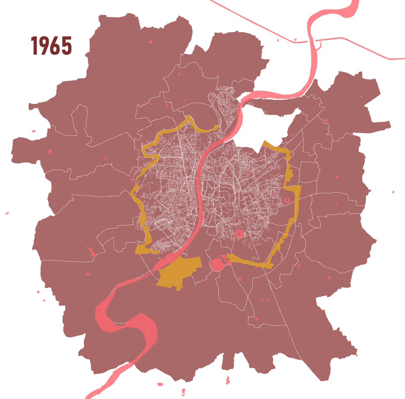
Greenbelt of Ahmedabad
Planning process byproduct
Story so far

preserving polyculture
Intent: To re-imagine the site that can continue to host all existing activities while creating opportunities for new ones to co-exist with the current and projected development around by employing the power and potential of urban memory.

Power and potential of Collective Urban Memory
The lands under greenbelt lay vacant for about 30 years due to lack of policy and ownership disputes between government and the khedut association. During this period the city grew past the greenbelt adapting around it with systems and activities emerging on these lands ranging from everyday to seasonal that cater to both neighborhood and regional scale. People playing cricket during morning or evening attracts hawkers and food vendors, a fair or festival attracts small businesses- few of the several examples wherein we can observe activities attracting other forms of engagements that lead to regularly functioning systems Everyday use of the land varies from being a playground to a karate training ground to a driving practice ground while for others it becomes a space to park their vehicles or carts for vending.. These practices, everyday or seasonal, craft an identity for the land in the city.. The fast emerging monocultural nature of developments with fixed uses around these lands slowly lead to disintegration of the inherent polycultural characteristics of these spaces.
User defined land identities as stimulants for social reform
These lands have operated with a sense of plurality, where the same space connects differently with different people based on the activities they participate in, generating new identities for each individual.. Mirchi Maidan, for neighborhood residents, creates a mental image of the ground near Vadaj circle. It not only caters to the spice market but also acts as a playground or holds temporary yet repetitive activities such as a fair.
Since the dispute resolution in 2013, new developments with singular uses have emerged rapidly. This new planned development neglects the existing uses that these lands hold. The existing activities are present because of the vacancy of the land caused by the dispute and the lack of policies. For as long as these lands remained vacant, they constantly generated opportunities for multiple uses. These uses were not limited to the neighborhood but extended to different parts of the city. As a user, these contrasting monocultural developments make the space feel empty as opposed to its vacancy which created value in this land with it’s adaptability.
Choked imagination dictating monocultural development
The monocultural development of the land is negligent towards the vacancy phenomenon. According to Vacancy and the Landscape: Cultural Context and Design Response by Carla I. Corbin, ‘Any fragment of land, no matter how unobstructed the view across its surface, is inhibited by its cultural or natural history.’ In line with this thought, the attempt is at re-imagining these lands with preservation of it’s cultural history and memory..
Polycultural habitats evolved from traces of current systems
By retaining the existing activities and systems in contrast to the new monocultural development, I intend to treat these greenbelt land parcels such that they can boldly exhibit their polycultural operation.
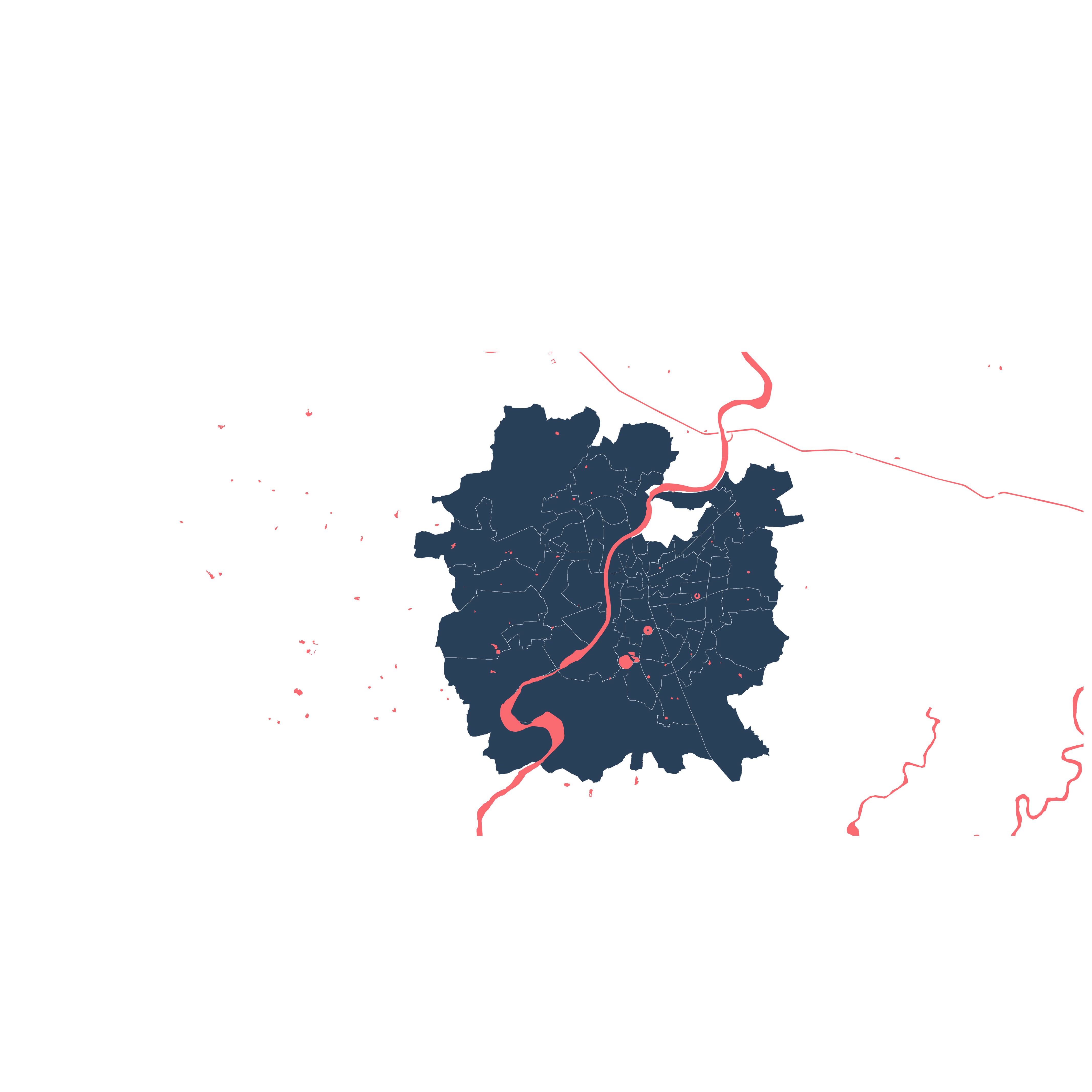
The site for intervention is located in the west of Ahmedabad and has traces of multiple activities and experiences of the past but is also currently under rapid development process.
Greenbelt has experienced vacancy for about 40 years due to the failed policies and disputes between government and land owners.
The greenbelt dispute ended in 2013, resulting in rapid development in and around the greenbelt.
During this vacancy of 40 years, the city has adapted and grown past the greenbelt and encroachment on it can also be seen with only traces of greenbelt lands remaining on the western part.
Site Introduction
Site context shows different type of open space which can be linked through the greenbelt to create a larger network.


Several activities have existed during its vacancy ranging from everyday to seasonal activities, each rendering a different identity to this space that differs from user to user. A system of co-dependency between these activities has also existed, some primary ones becoming initiators for other activities to grow on site.

Image by: Auto Educare and Kiran Parmar
The dispute over greenbelt ended in 2013 which resulted in rapid development of the site being filled with monoculture. This monocultural development disrupts the existing polyculture on the site, taking away the memory of the user. TP schemes have a potential to last for years and with the current planning structure, it further supports the monocultural development.
Restructuring of TP Scheme
Tp Schemes govern rural to urban land development, and because of the dispute, greenbelt land never went under development. Now this agricultural land is being converted to urban, but it is in the middle of the city.
Resolution of dispute over Greenbelt land and further development began based on the proposed TP schemes. As per resolution in 2013, 40 percent of the greenbelt land is under government and the rest 60 percent was given back to the private owners. TP schemes are a powerful tool to intelligently direct developments incrementally over the years to achieve the final vision for the city.


The current TP Scheme plan ignores the greenbelt as an entity, and just tries to connect the two adjacent sides in a fairly standard approach.
Instead, government owned land could be pooled to create a space that carries forward some of the existing polycultural uses on site, and creates opportunities for more.

Once pooled, this new organization satisfies the policy requirement of the TP Scheme, but also recognizes and leverages the vacant greenbelt space for its potential as an urban element, by creating a large open space that moves along the belt.
The project looks at this potential in restructuring the TP Scheme to create a network of open spaces between east and west of the site by linking it through the greenbelt.

Strategy
The strategies are divided into 2 scales, at 1000 scale formal strategies are applied to restructure the TP scheme to enable formation of the larger r network and at 200 scale functions are added to the created space which will retain the site memories while generating opportunities for the new to emerge.
The formal strategy is further divide into 3 parts
Existing Geometries
Access Points
Open Space Network


The access points that open up on the site are connected with the grid formed by extending the existing geometries that helps in creating hierarchy of open spaces.
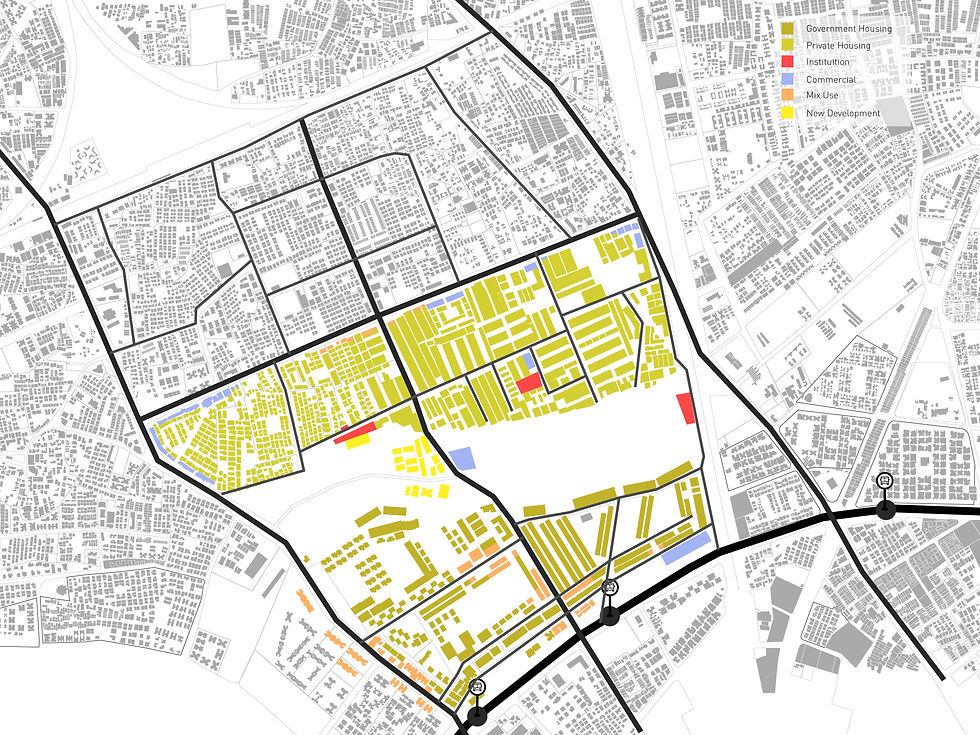
The space for intervention is carved out tracing the existing site trails and tree geometries to position different spaces like maidan, parks or party plots. These help create a public space that celebrates the role of greenbelt in retaining the polyculture on these lands today.

Activities
Green belt policy of Ahmedabad produced lands that are associated with a lot of nostalgia amongst it’s users formed over the years due to its capacity to accommodate several kinds of activities, predominantly through it’s adaptability that allowed these parcels to renew their operation continuously and facilitate multiple overlapping functions. The TP scheme on the other hand overlooked this aspect to propose formal restructuring that allowed only rigid singular uses. This contrast disregards all the existing patterns which could be the potential catalyst towards making a more connected city. This project tries to retain all those urban memories and devises strategies for public spaces that could grow intelligently to other parts of the city through the network of open spaces over the coming decades.


Open space adjacent to Primary vehicular road, cater to activities that are used by different parts of the city.
It can be an everyday activity or a seasonal event such as a market or a community gathering.
Open space adjacent to residential buildings cater to the users living nearby, but it is accessible for all.
Private Plots follow the GDCR guidelines for common plots that are divided into private and semi-private open spaces.
A continuous pedestrian path that passes through greenbelt and connects to different open spaces present around the site creating the open space network.
Contours create a visual buffer as the current site has vegetation that does the same. This helps in creating space for different user groups. For example, the contour cuts vision from the more public area and has a visual access from the buildings nearby making it suitable for the kids living nearby.
Pedestrian walkways have transition spaces that can allow different time based activities like hawkers and different types of vendors.