Simultaneous Stories So Far...
Urban Assemblies: the vacancy Phenomenon
Greenbelt of Ahmedabad
Planning process byproduct
Story so far
Shock Absorbers for the city


empathetic approach towards Town Planning Mechanisms
The stress of current fast-paced developments in cities have slowly led us to a point where we are looking at irreversible damage to nature resulting in larger problems of the climate that we will soon need to address. . The project demonstrates the potential in the relationship between the vacant lands and city that operates with the absorption of various urban stresses generated with heavy developments, diminished natural air and water quality, decreasing open spaces or limitations in enjoying a healthy public life. The project works in thresholds to offset each of these stresses with an empathetic approach towards the Town Planning mechanism where the natural systems are respected along with preserving the openness of the vacant spaces.
project vision

To reimagine the future of greenbelt development that preserves the existing quality of openness of vacant spaces and is indeterministic.
To demonstrate conditions and strategies where the urban green infrastructure not only preserves the characteristics of the vacant spaces but exhibits qualities that can soak up the urban stresses and operates to mitigate them locally.
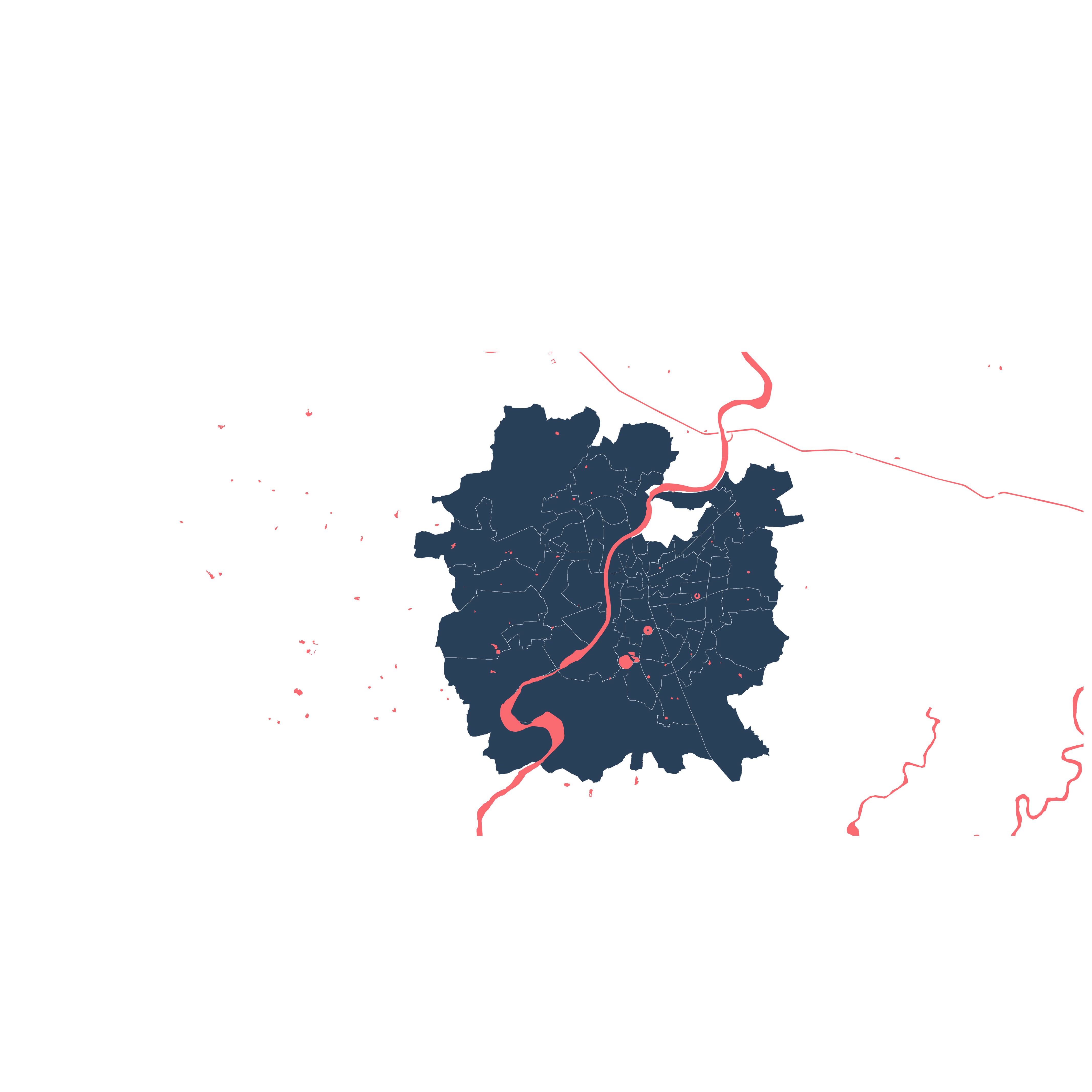
Ahmedabad's Greenbelt
In Ahmedabad, industrialization was at its peak and so was the migration of people to the city. The city kept growing without much planning and direction. Hence, the idea of a greenbelt seemed a suitable option for controlling Ahmedabad's urban sprawl, accommodate a growing economy, and as green lungs for the city amidst the industries. The development plans were laid out but were myopic in terms of future needs and towards the growth of urban boundaries with increasing population. Greenbelt was introduced in 1965 and was reserved for a decade till 1975. Later on, since no acquisition of land took place the un-making of the greenbelt began.

Vacant site with development coming up

cricket - weekend activities

Temporary tarpaulin homes
There has been a lack of policies for protecting the greenbelt along with an inconsistent policy framework which is constantly under amendments, ongoing compensation battles, and erratic decisions of the Development Plans for Ahmedabad. As a result, the city sprawled haphazardly, beyond the limits of the city and encroachments soon took over the lands which remained vacant for years before it was nullified. The making of the greenbelt was rather short compared to the unmaking of the greenbelt. During the time, India was still in the process of making and implementing city administration and development plans which lacked experience and foresight.
Jivraj park Greenbelt, Ahmedabad

As a result of all these factors, the city soon identified these lands as respite grounds for activities and things that were difficult to do in the otherwise dense neighbourhoods around. With the lack of open spaces, these became release points for the people who inhabited these spaces without any objections by landowners. If the TP schemes are implemented these spaces would soon be lost to the same type of dense development as opposed to now wherein these open spaces act as shock absorbers for the city’s social and cultural needs. Loss of these spaces will result in its loss of multiplicity and different identities each of the places developed over the years leaving traces of its use by the people.
Development Pressure on the Greenbelt
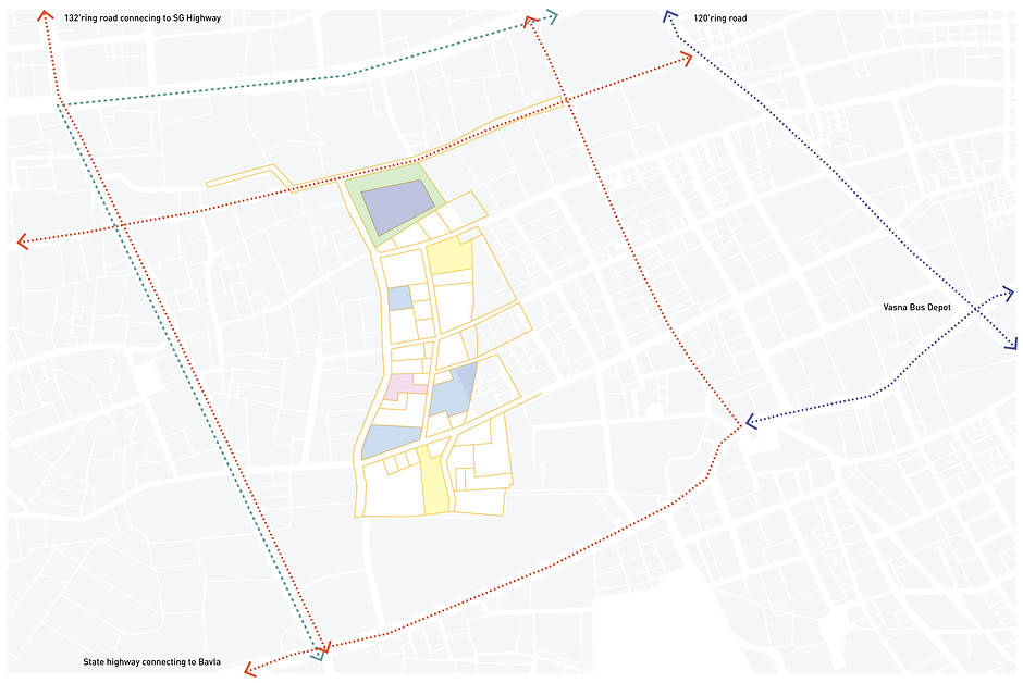
The existing town planning scheme is proposed for public and private development. FSI 4 has been proposed for the greenbelt development due to the upcoming TOD and to accommodate the pressures of future development.
Total area of the Jivraj park Greenbelt - 20ha (2,07,866sq.m)
Area of lake - 1.5ha (15,325 sq.m)
Area of public space around lake - 3 ha (30,745 sq.m)
Area of built proposed - 16.9 ha (1,69,450 sq.m)
Area of roads - 3.8 ha (38,420 sq.m)
Total area of government plots - 7.5 ha
Total area of Government owned land = 11.3 ha (1,13,042 sq. m)
Urban Lake condition
190.8 sq.km
464 sq.km
YEAR
1999
630 lakes
YEAR 2015
122 lakes
Comparative ratio of urban area to water bodies in the city (lakes)
Meanwhile, Ahmedabad's water bodies are also vanishing day by day. Some are a result of climate change others a consequence of the systematic exclusion of water bodies in the city. The problem here is that it is always seen as a piece of land for urban development and accordingly certain monetary value gets assigned to them. This has worked against the conservation practice and that's how a lake gets killed. There are many ways to define a lake in India. According to the National Plan for Conservation for Aquatic Ecosystems (NPCA), a water body having a minimum depth of three meters, spread over more than 10 hectares, and having no or very little aquatic vegetation, is considered as a lake. However, there is no clear def i nition including the urban lakes in the city which increases the risk of these lakes disappearing. Currently, this doesn't include the urban lakes within city limits and there is an urgency to protect and restore these lakes.

Lake with Boundary and development creeping in the surrounding. Decreasing surface water.

Desperate need to keep people out of a 'public space' even though they have no shelter.
On an average Ahmedabad receives 800mm - 900mm of rainfall during the rainy season of Monsoon from June to October. These lakes can collect rainwater by connecting the stormwater drainage of the neighbourhood. It can rejuvenate and restore the lakes around the city which otherwise goes to waste. A mechanism needs to be put in place which can protect the lakes from not only such unprecedented development but also help them restore their natural condition to act as ecological shock absorbers.
Manifesto

Situation
Greenbelt was made as part of a paradigm shift in order to control urban sprawl in the early 1930s. The lack of policies for protecting the greenbelt, inconsistent policy framework which is always under amendments as per the need of the time and ongoing compensation battles, and erratic decisions into the invaluable vacancy across the city.
It acted as a temporary market, pasture, playground, parking, storage and also a place for anything that is not needed in the city, ironically both people and things. These vacancies provide an opportunity for a place of abode for the communities who have no choice elsewhere.
Position
Shock Absorbers as an invaluable resource
Greenbelt failed as a mechanism at a planning level but it gave rise to uncertain, loosely held spaces due to contestations and ownership conf l icts that are invaluable land resources as vacancies. This failure unfolded lands that act as shock absorbers for the city where the city could not take pressures of housing problems, open green spaces which was the intent of greenbelt and day to day activities like being a playground, home for animals, as a guide to driving lessons, a storage facility for construction equipment and so on. The absence of these spaces will result in the loss of multiplicity that these activities brought together and the city will need to develop infrastructure to provide for such activities to take place elsewhere.
Accommodating the excluded
These vacancies are under a threat of ongoing development highly exclusionary, rigid and overly determining. The non-normative spaces are being replaced by normative spaces. The nature of these developments as a public space is quite linear and inclusive of only a few sections of the society. These non-normative spaces have reflected the stories of people who have been using them for decades, gradually becoming a part of their identities. These vacant lots are sites where the regulations are loose, and they often become places that are claimed by the marginalised communities or result in marginalised spaces.
Multiplicity counters Capitalism
These faces are being lost to the faceless development that is taking place over these vacant lands. These faceless visions are of those who can already afford them. Capitalism has given rise to the ‘crisis of abundance’ of such spaces that has resulted in the luxury of choice of normative spaces. Moreover, the public spaces owned by the state too offer a certain degree of exclusivity. Since most of them are gated and charge nominal fees, they exhibit the authority’s dire need to protect these gardens from a section of the very people for whom they are made.
We need to stop creating a singular, clean set of identities but to celebrate its multiplicity. “When things are made clear and defined, we forget”, Walter Hood. This holds true to the development that is coming up in these vacant lands.
Intent
“Great things can happen when we exist in each other’s world” - Walter Hood
Transient character empowers the idea of adaptability
Given that the new development is inevitable, how can we create an open system through which vacant spaces can demonstrate/exhibit as an alternative to faceless and gated public spaces?
A place that is transient and allows ‘conf l ict and dissonance’ for its growth can result in a place in the constant making - a dynamic form.
'Public' made 'Visible’
We need to capture these characteristics of vacancies that offer alternative urban commons in the city reflecting its multiplicity before it's taken over by faceless developments. Let them be democratic public spaces! - not in the legal sense, but as a tactile experience. Let us be empathetic where different sections of society can coexist and learn and interact with each other. Let us make visible, the invisible people and their living stories, through these public spaces.
The intervention in these spaces needs to be minimal which does not alter the nature of publicness and maintains the openness and uncertainty of the vacant lands. The need not be imposing but rather allows these multiplicities to exist and lets the identity of people who use them unfold.
“Cities have the capability of providing something for everybody, only because and only when they are created by and for everybody.” - Jane Jacobs
// vacant lands as as an invaluable resource for ecological and social shock absorbers
// Protection of Urban Lakes
// Multiplicity of uses
// Transient character enabling adaptability
Strategy
Re-imagining greenbelt vacant lands as potential sites to introduce an urban wetland infrastructure that would preserve the characteristic openness of vacant lands while also integrating the larger system with the operations of an adjacent urban lake (Malav Talav).
This framework is built with a three-pronged strategy approach - f i rst being the introduction of the urban wetland infrastructure, second being the integration with the urban lake for its ecological remediation and restoration, and lastly, building in the public urban commons within the first two strategies to create non-exclusive spaces along with the infrastructure that are indeterministic providing space for future shocks.

Context
Built
Accessibility
Wetland and Public space
2.1 DEVELOPMENT DIRECTION according to the contextual needs of the wetland.
1. WETLAND as a means to preserve the vacancy through a large urban blue-green infrastructure and to strategize the integration of public space within
1.1 OPEN SPACES amidst the urban green infrastructure and in between the development
2. ACCESSIBILITY to demonstrate different conditions with respect to the wetland and storm water drainage.
Through landform modif i cations and water system integration with the existing lake as the primary steps, the project implements a wetland system integrated with the urban lake Malav Talav on the site that would overtime generate a green infrastructure around it and resulting open spaces within The characteristics of openness of these vacant lands are captured through these indeterministic linear continuous green spaces emerging along the wetland and secondary pockets of open spaces in between the buildings.
Site runoff and Wetland Conf i guration


The employed geometry of the wetland is derived with exaggerated modif i cations of the existing site level conditions to enable optimal cut and f i l l processes. Intervening further into this primary level geometries give rise to small pockets in between the wetlands and seasonal recharge ponds while the spaces in between remain open. These pockets are created around the lowest points of the wetland and would result in conditions that largely inhibits development in the surroundings.
This site is re-imagined to take in the anticipated future shock that the city that will face arising from acute lack of large consolidated open public spaces.
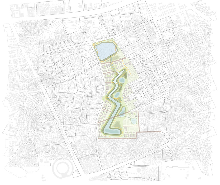
Area of wetland - 1.8 ha (18,683 sq.m)
Area of seasonal recharge ponds - 1 ha (10,098 sq.m)
Area of open public space - 5.5 ha (55,663 sq.m)
Area of Built - 2 ha (20,790 sq.m)
Area of streets - 1.3 ha (13,121 sq.m)
In-between Open space - 8.4 ha
With a permanent water infrastructure placed on the site, it allows for open spaces to remain open. Through this strategy, the openness of the vacant spaces is preserved as an accessible public space. With the reconf iguration of the Town Planning Scheme and the same amount of Public land used, the resultant outcome is an empathetic and sensitive approach towards the city’s natural systems and public life. This strategy allows remediation and protection of Urban Lakes in the city that are under threat of vanishing. Similar big open spaces in the city will be the relieving points in contrast with the dense neighbourhoods. This area of building footprint is also reduced to promote vertical development and have more open spaces on the ground.
Built Strategy


The buildings are oriented towards the wetland as the main public space. The streets are aligned along the contour so the natural f low of surface runoff can be enhanced.
Modif i cation of natural undulation

Considering the natural gradual contours and enhancing and protecting the surroundings, the contours are modi f i ed to accommodate wetland, enhance storm water drainage and create undesirable condition for development.
Wetland and seasonal recharge pond (for stormwater treatment)

Constructed wetland treats sewage water to the point that is safe, using mainly subsurface vertical flow of water. The wetland has a precautionary overflow of water. The edges have a continuous green open space as porous public space. The undulations employed to create these different edge conditions have uplands that stay dry throughout the year that can accommodate the permanent activities. Marshes restrict permanent development to be built and the seasonal recharge ponds which turn to maidan (playground) during summers and fills up during monsoons - so the users witness seasonal changes in the way these lands allow inhibition and operation.

The Wetland and the recharge points results in a certain configuration of land that is made available for development. Due to its proximity to the recharge ponds or the wetlands and not enough space for construction it remains empty. This gives people an opportunity to use and appropriate the space as they desire.

Marshlands are the edges along the wetland and the built. They act as transition spaces between a recharge pond or a wetland and land otherwise. Since, the land is filled with water and quite muddy, they remain as open spaces. These become an ecotone for different species to interact and enhance the ecological diversity of the space over the years.
Wetland and seasonal recharge pond (for storm water treatment)

The uplands along the wetlands are not only a precautionary measure to control overf lowing but they act as open maidans (playground). These spaces are continuous and accessible from the surrounding. They remain dry most of the year which makes them usable all year round for different activities or large gatherings, to be appropriated by the people as and when required.

Uplands might have marshes along the edge of the wetland from keeping people from directly access the wetland. These can be used where there is a risk of toxic water or contaminated water being released in the wetland. The pathways act as a continuous walkway around the site. The undulation act as a way to break down the spaces, restrict access and guide people to usable spaces without the use of walls or fences.
Urban Lake edge

Removing the concrete edge around the lake and walls to make it a natural edge. The public space is continuous and porous without any physical barrier. The vegetation on the edge is planted strategically to restrict people accessing the place at specific locations. The lake is connected to the wetland system through a channel that goes underground in case of a street passing.
The lake edge is made natural with hydrophytes to revive the ecosystem of the lake. Integrating it with the wetland is a way to remediate and protect these urban lakes from further encroachment. Friendly connection to the water is introduced along the lake edge with minimal interaction by touch and the edge is made higher as a flat land so it can give space for activities of certain kind and scale to take place.

The greenbelt has only remained vacant on the west side of Ahmedabad. Town planning schemes are being made for future developments. The larger concept of shock absorbers can be reproduced at different locations from the site of Jivaraj Park with modif ications based on contextual conditions. These sites have the potential to remain open as an ecological shock absorber and also preserve open spaces as public spaces.
Future expansion
